Walks & Parks
-

Colonial Knob Walk
Climb to the summit of this 468 m peak for views on clear day from the Inland Kaikoura Range in the south to Mt Taranaki in the north-west - it's a good option for older children. 3-5 hr return. You'll think you've sprouted wings when you reach the top of the 468 metre high hill rising to the west of Porirua City. From this lofty perch on a clear day you can view many other high points - from the Inland Kaikoura Range in the south to Mt Taranaki in the north-west.
read more- Location: Rangituhi
-

Barrett Domain and Lake Mangamahoe, New Plymouth
A good venue for a family day out - pack a picnic and hang out on the shores of Lake Mangamahoe. There are lots of walking and easy mountain bike tracks. It takes about 2 hours to walk the round the lake circuit, and there are some undulating sections so reasonable fitness is required. There are other walks that take 10-20 minutes, and a section of dedicated mountain bike trails.
read more- Location: nr Egmont Village, New Plymouth
-

Kauaeranga Valley hiking trails
The Kauaeranga Valley is located 15 minutes out of Thames and is a beautiful and historic location for the entire family. With walks/tramps that last from 10 minutes to a full day, a well informed visitors centre, camping, cottages, swimming holes, a café through summer and canyoning, there's activities to suit everyone.
read more- Location: Kauaeranga Valley, 15 minutes from Thames
-

Whareroa Farm tracks
Enjoy regenerating shrubland, coastal views and kohekohe forest on these walks that are suitable for children. Walks range from 355 metres to 13.4km - there is something for everyone. Plus some great mountain bike tracks to play on, and even a horse riding track. Lots of room to play!
read more- Location: Whareroa Farm, Queen Elizabeth Park off-ramp about 3.5 km north of Paekakariki on SH1.
-

The Coastal Walkway, New Plymouth
This is an excellent, completely flat walkway that is also perfect for family bike rides. You can start the walk from the middle of New Plymouth, just in front of the iSite, and head alongside the Tasman Sea towards Bells Block. You will pass the famous, 45 metre Wind Wand sculpture along with a number of interesting stone carvings, before passing the popular surf beaches of Fitzroy and East End. There are plenty of good picnic spots and a playground enroute, before you arrive at the must-see Te Rewa Rewa Bridge. From the town centre, if you head in the other direction - west, the walkway winds past the Todd Energy Aquatic Centre, Kawaroa Park and playground then heads to the marina at the port and Ngamotu Beach - a safe swimming beach for the family.
read more- Location: New Plymouth, Taranaki
-

Makara Walkway
This loop walk climbs to vantage points with spectacular views - farmland, a beach and gun emplacements will keep kids interested.This 6km loop walk climbs to vantage points with spectacular views, and returning along the beach. The high cliffs and spectacular views for centuries have provided the people of the area with good vantage points for the defence of their land. A Ngati Ira pa site lies on the promontory at the western end of Fisherman's Bay, and gun emplacements at the top of the cliffs mark the position of Fort Opau, which was garrisoned by 100 soldiers during World War II.
read more- Location: 1099 Makara Rd, Makara Beach, Wellington 6972
-

Best Beaches :: Taranaki
Round up the family and head to one of the region's superb beaches! Great choices include Back Beach, Centennial Drive, East End Beach, Nobs Line, Fitzroy Beach, Beach St, Ngamotu Beach, Ocean View Parade, Oakura Beach, Jans Terrace, Oakura. East End, Fitzroy and Oakura are the only beaches in New Zealand to be awarded the Blue Flag eco-label for their environmental, education and safety status.
read more -

Pukekura Park, New Plymouth
Wander through this inner-city botanical wonderland to discover lakes, a zoo, historic tea house, playground and countless short walks, as well as a Fernery and Display Houses and a Japanese-inspired hillside.
read more- Location: Fillis Street, New Plymouth
-

Bason Botanic Gardens - Whanganui
Bason Botanic Garden is rated a “Garden of Significance” by the New Zealand Gardens Trust. It includes one of the most extensive public garden orchid collections in New Zealand. Families enjoy their time here making use of the wide open spaces and free gas BBQ facilities.
read more-
Location:
552 Rapanui Rd,
Westmere 4574
Whanganui
-
Location:
552 Rapanui Rd,
-

Whinray Scenic Reserve
There a couple different options to custom fit this trail to your time frame. Either a 30 minute walk from the car park on Motu Falls Road or a 2.5 hour walk from Marumoko Road to the Motu Falls Car Park.
read more- Location: Motu 4092
-

Mount Taranaki Walks
A must-visit of the region is the Egmont National Park and there are plenty of short walks around the foothills or sides of Mt Taranaki (also known as Mt Egmont). During summer you can also tackle the all-day hike to the summit (very strenuous, 8-10 hours return, 2518m).
read more
The two 'starting off' points for day hikes are North Egmont Visitor Centre, nearest village Egmont Village, or Dawson Falls Visitor Centre on the southern side, nearest town, Stratford.
From here you can choose a walk or hike to suit your family's ability and fitness, from just a few minutes to 10 hours (Mt Taranaki summit climb). Some of the 3-4 hour walks are long enough to get you up high on the mountain with amazing views of the summit and right across flat farmland to the sea. They are short enough to be do-able for reasonably fit families. There are also overnight huts on the mountain and the most famous multi-day tramp is the Around the Mountain Circuit (4-5 dayas)- Location: Mt Taranaki National Park, nr New Plymouth
-

Banks Peninsula Walks
This awesome and easy to explore site lists all the walking and tramping tracks on beautiful Banks Peninsula near Christchurch, New Zealand.
read more
Includes Lyttelton, Akaroa, Governors Bay and Diamond Harbour.- Web: www.bankspeninsulawalks.co.nz/
- Location: Banks Peninsula, Canterbury
-

Matiu / Somes Island Loop Track
Island walking! The kids will love the ferry ride from Queens Wharf and this easy 40 min walking track has plenty to keep kids interested. This loop track around Matiu/Somes Island offers 360 degree views of Wellington harbour - with native wildlife, remnants from the world wars, historic quarantine buildings, and a lighthouse. The island is open to the public from 8:30 am to 5:00 pm daily. This track takes you around Matiu/Somes Island, offering spectacular views across Wellington Harbour to Wellington and Hutt cities. Pause along the way to check out the island’s historic and ecological attractions, including introduced wildlife which are thriving in native vegetation planted by Lower Hutt Forest and Bird since 1981.
read more- Location: Wellington Harbour
-
Avalon Park
Avalon Park is a six hectare park has a great range of features, including the Avalon Park Playground which is open every day and is free. Aimed at preschoolers to 12-year-olds and designed to appeal to families. It has a mix of contemporary and traditional play equipment within a specially-designed landscape. Plus there are lots of other activities to keep the whole family entertained, including beginners’ cycle circuit with various intersections and surfaces, model train (charge applies), mini putt golf, skate park, model marine boating pond, public tennis court, sculptures and more. Make use of the free electric barbecues and picnic tables. Spend the day and play!
read more- Location: 61 Taita Dr, Avalon, Lower Hutt 5011
-

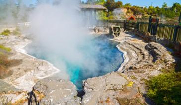
Taupo -Tokaanu Thermal Area
Just five minutes from Turangi is the village of Tokaanu. A short walk around the loop track on well formed paths and boardwalks allows you to see steaming hot mineral pools and bubbling mud pools. Take a picnic with you as there are areas for picnics and fishing. You can swim in the nearby Tokaanu Thermal pools at Mangaroa Street and there are often rainbow trout swimming in the cold Tokaanu stream which flows beside the thermal area. As with all thermal area, children should be supervised at all times.
read more- Location: Tokaanu Thermal Area, SH41, Lake Taupo
-

Horseshoe Bend Track, Roxburgh
This track ( 1.5 hour return) leads to an historic suspension bridge over the Clutha River. The village once here in this gold mining area was known as Rigney and the miner’s children needed to cross the river to get to school. Rather than brave the swift current with a boat, first a wire cage was installed but when this proved difficult, the bridge you see today was constructed in 1913. It is remote and can be a wild area but the peacefulness and spectacular river views are well worth the effort getting here. Take care on the bridge but enjoy crossing before returning the same way. Access from SH8 through the area known as Island Block. This route has excellent views of the river and recent gold dredge ponds. Whilst in this area, drive 1 km further on this road and view the ‘Lonely Graves’, located beside the road with a car park adjacent. There are two graves here. According to the story in 1865 William Rigney found the body of a good looking young man in the river. He buried it here with the headboard inscribed ‘Somebody’s Darling lies buried here’. When William died in 1912, he was buried beside ‘Somebody’s Darling’.
read more
-

Estuary Walkway - Invercargill
Walking/cycling loop track through the estuary margins (access off Stead Street). Well-formed gravel track (approx 5.5km) with boardwalks, providing views of the estuary. Interpretive panels, seating and shelters are along the track.
read more- Location: Invercargill, Stead Street
-

Chisholm Park - Dunedin
Follow the beach region out towards the Dunedin golf course. From here you can walk a gravel track through the golf course and on towards Lawyers Head with its spectacular sea views, or Tomahawk beach – a beautiful, secluded spot. Suitable for buggies, but there are sheer cliffs near Lawyers Head.
read more- Location: Dunedin - nr St Kilda Beach, South Dunedin
-

Hawkes Bay - Lake Tutira
Forty kilometers north of Napier is Lake Tutira. The area surrounding this lake is a bird sanctuary and makes a wonderful picnic and camping spot. There are toilet facilities and a free campsite with fresh water and barbecue facilities. The Tutira walkway is steep and not suitable for young children or pushchairs (the round trip takes about five hours!), but there is good swimming in this very pretty lake and trout fishing in the lake’s northern reaches.
read more- Location: Between Napier and Wairoa
-

Hauraki Rail Trail, Paeroa to Waikino
This is a 2hr - 14km bike ride ( a section of the 160km 2-4 day trip). Ride through the historic and scenic Karangahake Gorge past gold mines and through the 1km long tunnel.
read more- Location: Paeroa
-

Auckland Domain
The Auckland Domain is probably best known for the annual CocaCola Christmas in the Park extravaganza. This 75 hectare park is Auckland’s oldest and has been developed around an extinct volcano. There are duck ponds, sportsfields and the Auckland War Memorial Museum is located right in the middle!
read more- Location: 20 Park Road, 21 Domain Drive, George Street, Titoki Street and 72 – 80 Stanley Street, Parnell
-

Blue Lake Loop - St. Bathans
There are a couple of options around the Blue Lake area in St. Bathans - the 2km, 50 min option will take you on a loop that skirt a portion of Blue Lake. A 3km, 90min return option will take you all the way around Blue Lake.
read more-
Location:
Blue Lake
St Bathans 9386
-
Location:
Blue Lake
-

Craigieburn Forest Park and walking tracks
Short walks in Craigieburn Forest Park range from a 20 minute nature walk to a 3-4 hour walk to the top of Helicopter Hill. About 110 km from Christchurch on SH 73 towards Arthur’s Pass, is a signposted side-road to the Craigieburn picnic area on the Broken River ski field road. This picnic area provides nice spots to have lunch, explore and paddle in Cave Stream. From here you can walk along the road to the Environmental Education Centre (suitable for buggies and strollers) and the start of the Craigieburn Nature Trail (20 minutes return) a pleasant walk through mountain beech forest.
read more- Location: 110 km from Christchurch on SH 73 towards Arthur’s Pass.
-

Rotorua - Kuirau Park
This informal park of about 30 hectares is only about five minutes walk to the city centre and has playing fields, a refreshment kiosk, a fountain, a miniature steam railway and children’s play area. You can see boiling mud pools and hot steaming crater lakes in the park and the large garden area has an ornamental lake and geothermally heated foot pools where you can soak your tired feet! A walk throughout the park will take about 40 minutes.
read more- Location: Ranolf Street, Rotorua
North Island
South Island
- Central Otago
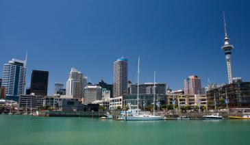
- Auckland
- Bay of Plenty
- Christchurch
- Dunedin
- Coromandel
- Gisborne
- Fiordland
- Hawkes Bay
- Marlborough Sounds
- Manawatu
- Nelson & Golden Bay
- Northland
- North Canterbury
- Queenstown
- Rotorua
- South Canterbury
- Taranaki
- Southland
- Taupo
- Wanaka
- Waikato
- Wellington
- West Coast
- Whangarei
- Bay of Islands
- Tauranga
- Gisborne
- Hamilton
- Napier
- Kapiti
- Palmerston North
- Whanganui
- New Plymouth
- Arrowtown
- Te Anau
- Akaroa
- Ashburton
- Hanmer
- Kaikoura
- Methven
- Mt Cook
- Oamaru
- Tekapo
- Timaru
- Abel Tasman
- Motueka
- Nelson Lakes
- Blenheim
- Picton
- Catlins
- Gore
- Stewart Island
- Central Plateau
- Invercargill
- Cromwell
- Greymouth
- Hokitika
- Westport
- Glenorchy
Our favourite destinations…